
Short Answer
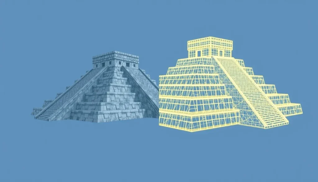
The ancient Maya city of Chichén Itzá, located on Mexico’s Yucatán Peninsula, stands as one of the most significant archaeological sites in the pre-Columbian Americas. While the monumental core covers approximately 5 square kilometers, the dense urban development at its peak is estimated to have reached 25 square kilometers. In recent years, the stewardship of this expansive site has shifted towards advanced digital methodologies. Through collaborative efforts between institutions such as the University of California, CyArk, and the Instituto Nacional de Antropología e Historia (INAH), Chichén Itzá has been meticulously documented using terrestrial LiDAR, photogrammetry, and high-resolution imaging to create a comprehensive digital record for future generations.
Main Explanation
The digital documentation of Chichén Itzá is not a singular event but a cumulative process involving multiple interdisciplinary projects. The primary objective is to preserve the site’s current state, aid in conservation efforts, and provide researchers with accessible data without the need for physical intrusion. Two major initiatives define this landscape: the Open Heritage 3D project and the Chichen Itza 3D Atlas.
The Open Heritage 3D project focuses on capturing specific structural data using high-precision equipment. For instance, terrestrial LiDAR scanning was conducted using devices such as the Leica SS1 Time of Flight Scanner. This technology emits laser pulses to measure distances with extreme accuracy, generating point clouds that represent the physical geometry of the ruins. The data generated from these scans is substantial; a single LiDAR dataset for the site can exceed 4.76 GB, ensuring that minute architectural details are preserved digitally.
Simultaneously, the Chichen Itza 3D Atlas project, led by researchers at the University of California San Diego (UCSD), aims to bring high-resolution 3D geospatial data together with over 300 models of architecture and artifacts. This initiative creates a full-resolution 4D digital twin of the site. The project aggregates data from various sources, including museum objects housed in the Palacio Cantón Museum in Mérida and the Gran Museo del Mundo Maya. By annotating each dataset with full provenance, the atlas ensures that the digital objects are scientifically valid references for archaeologists and conservators.
Another significant contribution comes from the INSIGHT project, which built upon data collected during the production of the planetarium film Tales of the Maya Skies. Funded by the National Science Foundation and the Instituto Politécnico Nacional, this interdisciplinary effort led to an open data archive containing photography and 3D models of objects and structures. This repository complements the geometric data with contextual articles and videos describing how to work with the data using open-source software, thereby democratizing access to the site’s digital representation.
Evidence & Sources
The validity of these digital documentation efforts rests on transparent data publication and academic citation. The Chichen Itza 3D Atlas is formally cited under the DOI 10.34946/D6B88P, published by the University of California in 2023. The project credits a vast team of contributors, including specialists from NCALM, CyArk, and various Mexican institutions, underscoring the collaborative nature of modern digital heritage.
Data availability is a cornerstone of these projects. The Open Heritage 3D portal provides direct download links for spatial data, ensuring that the 4.76 GB LiDAR files are accessible to qualified researchers. Similarly, the INSIGHT archive emphasizes open access, providing not just the raw models but also the methodology for their creation. This transparency allows for the verification of digital reconstructions against physical reality. For example, 3D scans of friezes in situ are contrasted with minimally invasive digital reconstructions, allowing scholars to test hypotheses about original coloring or structural integrity without touching the fragile stone.
Furthermore, the documentation extends beyond the archaeological zone to include artifacts distributed widely between collections since the initial excavation in 1913. By digitally reuniting these scattered artifacts within a virtual environment, researchers can study the corpus of monumental architecture, carved stone iconography, and painted murals as a cohesive whole, despite their physical separation across different museums and camps.
Deep Dive Analysis
To understand the technical rigor behind the documentation of Chichén Itzá, one must examine the specific digital archaeology workflows employed. This process transforms physical heritage into immutable digital assets.
Technology Description
The primary technologies utilized are Terrestrial LiDAR (Light Detection and Ranging) and Photogrammetry. LiDAR, specifically Time of Flight scanners like the Leica SS1, measures the time it takes for a laser pulse to return to the sensor, calculating precise distances. Photogrammetry involves stitching together hundreds of overlapping high-resolution photographs to create textured 3D models.
How It Works
In the field, surveyors establish control points using GPS to georeference the scans. The LiDAR scanner is set up at multiple stations around a structure, such as El Caracol or the Temple of Kukulcan, to capture a 360-degree view. These individual scans are then registered together in post-processing software to form a unified point cloud. Photogrammetry is often used concurrently to apply color and texture to the geometric mesh generated by the LiDAR data.
Field Workflow
The workflow begins with site assessment and permission acquisition from INAH. Equipment is transported to the Yucatán Peninsula, where environmental conditions like heat and humidity must be managed to protect sensitive electronics. Scanning sessions are planned to minimize interference with tourists, often occurring during early morning or closed hours. Data is backed up immediately on-site to prevent loss.
Output and Data
The final output includes dense point clouds, textured meshes, and orthophotos. The Chichen Itza 3D Atlas describes this as a 4D digital twin, implying the inclusion of temporal data or the ability to track changes over time. The data types available for download range from raw spatial data to processed models, with file sizes indicating high fidelity; for example, the LiDAR data alone is nearly 5 GB.
Strengths and Limitations
The strength of this approach lies in non-invasive preservation. Researchers can measure architectural features or analyze iconography without risking damage to the stone. However, limitations exist. LiDAR cannot capture internal structures without penetration, and occlusion (areas blocked from the scanner’s view) requires manual interpolation. Furthermore, the sheer size of the data requires significant computational resources to process and view.
Accuracy and Cultural Heritage Considerations
Accuracy is maintained through rigorous calibration and the use of proven industry-standard hardware. Culturally, these projects prioritize stewardship. By creating a digital backup, the projects safeguard the site’s memory against natural disasters or degradation. The open licensing of data, as seen in the Chichen Itza 3D Atlas, ensures that the cultural heritage of the Maya people remains accessible to the global community for education and study, rather than being locked behind paywalls.
FAQ
Is the 3D data of Chichén Itzá available to the public?
Yes, projects like the Chichen Itza 3D Atlas and Open Heritage 3D make datasets available to the public, often requiring registration to download large spatial data files.
What technology was used to scan the ruins?
The documentation primarily utilized Terrestrial LiDAR (such as the Leica SS1 Time of Flight Scanner) and photogrammetry to create high-resolution 3D models.
Why is digital documentation important for Chichén Itzá?
It creates a permanent record for conservation, allows researchers to study artifacts distributed across different museums, and aids in monitoring site degradation over time.
Leave a Reply