
Short Answer
The documentation of archaeological sites and artifacts has undergone a revolutionary shift with the advent of digital technologies. Traditionally reliant on hand-drawn plans and sections, archaeologists now utilize advanced 3D surveying methods to create precise, immersive records of cultural heritage. Two primary technologies dominate this field: Photogrammetry, specifically Structure from Motion (SfM), and Terrestrial Laser Scanning (TLS). While both aim to generate three-dimensional models, they operate on different physical principles and offer distinct advantages depending on the project’s scale, budget, and accuracy requirements. Understanding the nuanced differences between these methods is critical for archaeologists and digital heritage specialists tasked with preserving history for future study and public engagement.
Main Explanation
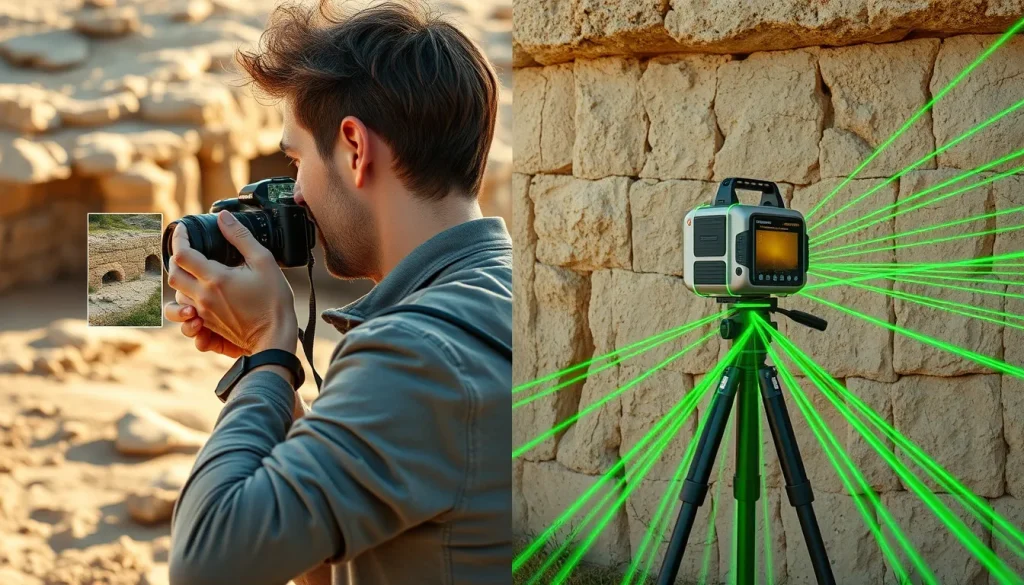
Photogrammetry and laser scanning represent the two pillars of modern 3D data acquisition in archaeology. Photogrammetry relies on the principle of triangulation using overlapping photographs. By capturing an object or site from multiple angles, software algorithms identify common points across images to calculate spatial positions, resulting in a dense point cloud that can be textured with the original photographs. This method is often accessible, requiring only a standard digital camera and specialized software.
In contrast, Terrestrial Laser Scanning (TLS) uses active remote sensing technology. A laser scanner emits beams of light that reflect off surfaces and return to the sensor. By measuring the time of flight or phase shift of the laser, the device calculates precise distances to millions of points per second. This creates a highly accurate geometric representation of the environment, independent of lighting conditions, though it often lacks the inherent color texture of photogrammetry unless combined with internal cameras. The choice between these methods often hinges on the specific needs of the archaeological investigation, such as the need for millimeter-level precision versus the need for rapid, low-cost documentation.
Evidence & Sources
Comparative studies provide empirical evidence regarding the efficacy of these technologies. A significant case study involved the documentation of a Roman mosaic from the 2nd century AD discovered in Cantillana, Seville. Researchers compared SfM photogrammetry against TLS to determine which method better served the need for exhaustive documentation and 3D recreation with real measurements. The study highlighted that while both methods produced viable models, differences in resolution and geometric accuracy were notable depending on the surface characteristics of the mosaic [1].
Further evaluation was conducted at the archaeological site of Aquileia in Friuli Venezia Giulia, Italy. The project aimed to test 3D surveying methods on ancient Byzantine city walls. The objectives included creating maps and sections useful for investigating architectural construction techniques. The researchers evaluated and compared photogrammetric and laser scanner data to identify the most effective approach for analyzing construction phases. This study emphasized the importance of selecting the right tool based on the architectural complexity and the specific archaeological questions being asked [4].
Additionally, informal comparisons in contexts such as indigenous Australian rock shelters have illustrated the relative merits of both technologies. Practitioners note that while laser scanning offers superior geometric fidelity in low-light conditions, photogrammetry often provides superior visual texture and color fidelity at a fraction of the cost. These combined insights suggest that a hybrid approach may often yield the best results for comprehensive digital recording [2].
Deep Dive Analysis
Technology Description
Both technologies fall under the umbrella of digital archaeology and remote sensing. Photogrammetry is a passive method, relying on ambient or artificial light reflected off surfaces into a camera sensor. TLS is an active method, generating its own light source (laser) to measure distance. The combination of these technologies is increasingly common to leverage the geometric strength of lasers and the textural strength of photos [3].
How It Works
Photogrammetry software uses algorithms to match features across overlapping images (typically 60-80% overlap). It calculates camera positions and 3D coordinates simultaneously. TLS instruments rotate mirrors or heads to direct laser pulses across a field of view, recording the XYZ coordinate of each reflection. Some modern scanners also capture RGB color data during the scan, but this is often lower resolution than dedicated photography.
Field Workflow
For photogrammetry, the workflow involves placing scale bars and control points on the ground, followed by capturing hundreds of images around the subject. Lighting must be consistent to avoid shadows that confuse the software. For TLS, the workflow involves setting up the scanner on a tripod, leveling it, and performing multiple scans from different stations to avoid occlusions. Registration targets are often required to align multiple scans into a single coordinate system.
Output and Data
Both methods produce point clouds. Photogrammetry outputs are often denser in textured areas but may struggle with uniform surfaces. TLS outputs are geometrically uniform but may have lower point density depending on the scanner settings. Both can be converted into mesh models and orthophotos for analysis.
Example Application
In the Cantillana mosaic case study, the goal was to recreate the mosaic with real measurements in a 3D model. The photogrammetric approach allowed for high-resolution texture mapping of the tesserae, while TLS provided a robust geometric framework. This dual approach ensured that both the artistic detail and the spatial integrity of the Roman artwork were preserved digitally [1].
Strengths
Photogrammetry is cost-effective and portable. A high-quality model can be generated with equipment many archaeologists already possess. TLS is superior in capturing complex geometries without reliance on lighting and can penetrate certain vegetation gaps better than cameras. It is also generally faster for large-scale structural surveys where setting up hundreds of photo stations would be impractical.
Limitations
Photogrammetry fails on reflective, transparent, or featureless surfaces (e.g., smooth water, glass, or blank walls) because the software cannot find matching points. TLS struggles with dark, light-absorbing surfaces and can be prohibitively expensive to purchase and maintain. Furthermore, TLS data processing can be computationally intensive.
Accuracy
High-end TLS systems can achieve sub-millimeter accuracy at short ranges. Photogrammetry accuracy is dependent on the camera resolution, lens quality, and the distribution of control points. In the Aquileia project, comparing the two data types was essential to validate the measurements used for archaeological interpretation of construction techniques [4].
Cultural Heritage Considerations
The ultimate goal of these technologies is preservation and access. Digital models allow researchers to study fragile sites without physical contact, reducing wear and tear. They also enable virtual access for the public and scholars who cannot travel to the site. However, the data must be stored and managed according to archival standards to ensure long-term viability. The combination of laser scanning and photogrammetry is often recommended for high-value cultural heritage objects to ensure both geometric precision and visual fidelity are maintained for future generations [3].
FAQ
Which method is more accurate for archaeological documentation?
Terrestrial Laser Scanning (TLS) generally offers higher geometric accuracy, often sub-millimeter, while photogrammetry accuracy depends on camera resolution and control points but can be sufficient for most archaeological records.
Can photogrammetry and laser scanning be used together?
Yes, combining both methods is often recommended for cultural heritage to leverage the geometric precision of lasers and the high-resolution texture of photographs.
Is photogrammetry suitable for dark environments?
No, photogrammetry relies on visible light. In dark environments like caves or unlit tombs, laser scanning or artificial lighting setups are required.
Leave a Reply