
Short Answer
Introduction to Digital Archaeology in Mesoamerica
Digital archaeology represents a paradigm shift in the documentation and preservation of cultural heritage sites, particularly within the dense jungles of the Maya region. There is an ongoing tension between the preservation of cultural heritage sites and the need for usable land, which necessitates advanced non-invasive recording methods. As a result, there have been several efforts to preserve these sites using current advances in scanning, modeling, and visualization technologies. These technologies include RGB-D cameras, scene reconstruction pipelines, and Virtual Reality (VR). However, historically, these individual technologies have mostly been developed independently, and little effort was dedicated to integrating them until recent interdisciplinary collaborations emerged.
The application of digital heritage methods in Mesoamerica serves multiple critical functions: conservation of endangered monuments, research into architectural planning, illustration for publication, and education for the public. By creating high-resolution 3D models, archaeologists can analyze surfaces and structures without physical contact, reducing wear on fragile stucco and stone. This digital turn allows for the virtual reconstruction of sites that may be inaccessible due to political instability, environmental degradation, or physical fragility. The goal is to take an unskilled user from data capture to an immersive virtual tour without the need for specialized manual modeling, thereby democratizing access to ancient history.
This article examines the methodologies, case studies, and technological pipelines that define the current state of 3D scanning and reconstruction of Maya sites. It draws upon significant projects such as the multi-sensor documentation of Copán, the Peabody Museum’s 3D Scanning Project, and the Palenque 3D Archaeological Atlas. Through these examples, we explore how digital tools are not merely recording the past but actively shaping our understanding of Maya cosmology, architecture, and epigraphy.
Technological Evolution in 3D Documentation
The evolution of 3D documentation in archaeology has moved from simple photogrammetry to complex multi-sensor fusion. Early efforts relied heavily on terrestrial photography and manual measurement, which were time-consuming and prone to human error. The introduction of terrestrial Time-of-Flight (TOF) laser scanners marked a significant advancement, allowing for precise geometric data capture. However, laser scanning alone often lacks the textural detail required for epigraphic analysis. Consequently, modern workflows integrate UAV (Unmanned Aerial Vehicle) and terrestrial images together with terrestrial TOF laser scanner data.
This multi-sensor approach is processed and seamlessly combined to produce a multi-resolution model which fulfills measurement and archaeological research needs. The integration of visual-inertial Simultaneous Localization and Mapping (SLAM) has further revolutionized data capture. SLAM technology allows cameras to track their position in space while capturing data, facilitating a more fluid scanning process. This is particularly useful in complex architectural environments like Maya temples, where line-of-sight can be obstructed by vegetation or structural collapse.
Furthermore, the development of RGB-D cameras has enabled the capture of both color (RGB) and depth (D) information simultaneously. This data is registered to perform a 3D reconstruction using registered depth and RGB data. The evolution of these systems demonstrates a trend towards automation and interoperability. Where once data processing required months of manual alignment, current pipelines aim to automate the reconstruction process. This technological evolution supports the creation of digital twins—virtual replicas of physical sites that can be manipulated, measured, and toured remotely.
Methodologies for Data Capture and Reconstruction
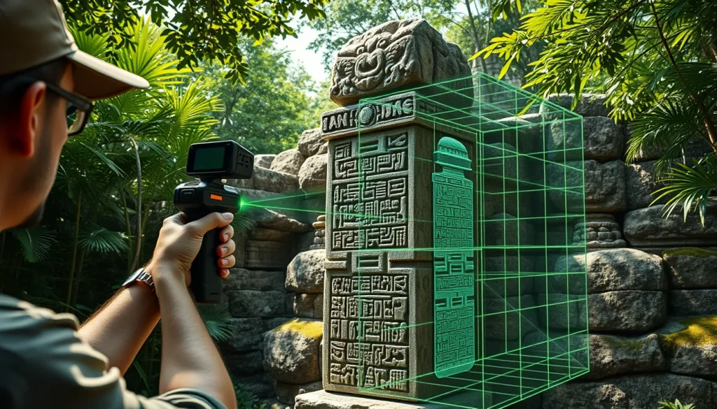
The core of digital archaeology lies in the pipeline used to transform physical reality into digital data. A robust pipeline typically involves four key stages: tracking, reconstruction, visualization, and interaction. To achieve this, researchers develop a pipeline to track the cameras using visual-inertial SLAM, perform a 3D reconstruction using registered depth and RGB data, facilitate loading and displaying the reconstruction in VR, and create virtual voice-guided tours. Each stage requires specific hardware and software protocols to ensure scientific accuracy.
Data Acquisition Protocols
Data acquisition must be systematic to ensure complete coverage. For large sites like Copán or Tikal, a combination of aerial and terrestrial methods is employed. UAVs capture overhead geometry and context, while terrestrial scanners capture fine details of facades and inscriptions. The Peabody Museum project, for instance, utilized high-resolution 3D models created for over 30 Maya sculptures from 10 different archaeological sites. This included fragile modeled stucco façades and the entire 64-step Hieroglyphic Stairway at Copan, Honduras. Documentation also took place at the archaeological sites of Tikal, Holmul, Cival, and Naranjo in Guatemala, and museum collections of Guatemala and United States.
Processing and Modeling
Once data is captured, it undergoes rigorous processing. Point clouds generated from laser scanners are aligned with photogrammetric meshes. Noise reduction algorithms remove vegetation or modern intrusions from the data. The goal of this project was to set the standards specifically for 3D scanning of Maya monuments as well as share the digital 3D data. Standardization is crucial for interoperability, allowing different institutions to share and compare data sets. Cloud-based visualization workflows are increasingly used to handle the massive data loads associated with high-resolution site models.
The Copán Multi-Sensor Documentation Project
The Maya site of Copán in Honduras serves as a premier case study for multi-sensor 3D documentation. An international and interdisciplinary project focused on the reality-based, multi-resolution and multi-source documentation and digital reconstruction of a part of the ancient Maya kingdom of Copán. This project will provide digital 3D models for research and public education purposes. The complexity of Copán’s architecture, particularly the Hieroglyphic Stairway, requires precision that single-sensor methods cannot achieve.
The Hieroglyphic Stairway
The Hieroglyphic Stairway is the longest known Maya inscription, comprising 64 steps covered in glyphs. Physical access is restricted to prevent erosion of the stone. Digital scanning allows epigraphers to study the glyphs in detail without touching the surface. The Peabody Museum’s collaboration ensured the entire 64-step Hieroglyphic Stairway at Copan, Honduras was documented. These models enable researchers to apply lighting models that reveal weathered carvings invisible to the naked eye.
Multi-Resolution Modeling
The Copán project utilized UAV and terrestrial images, together with terrestrial TOF laser scanner data were acquired, will be processed and seamlessly combined to produce a multi-resolution model. This multi-resolution approach allows users to zoom from a site-wide context view down to individual glyph details without losing geometric fidelity. Such models fulfill measurement and archaeological analysis requirements, enabling architects to study construction phases and masons to analyze tool marks on the stone.
The Peabody Museum 3D Scanning Initiative
In 2007 the Corpus of Maya Hieroglyphic Inscriptions (CMHI) research program at the Peabody Museum launched a 3D scanning project to document endangered ancient Maya monuments. This initiative was conducted in collaboration with several governments and institutions for the purposes of conservation, research, illustration, publication, and education. The project highlighted the urgency of digitizing sites threatened by environmental factors and looting.
Standardization Efforts
As the widespread application of 3D digitizing systems continues to expand within archaeology and cultural heritage management, a goal of this project was to set the standards specifically for 3D scanning of Maya monuments. By establishing protocols for resolution, file formats, and metadata, the Peabody Museum ensured that data collected in Guatemala could be compared with data held in United States collections. This standardization facilitates long-term preservation of the digital records even if the physical monuments degrade.
Site Coverage and Collaboration
The initiative covered a broad geographic range. High-resolution 3D models were created for over 30 Maya sculptures from 10 different archaeological sites. Documentation also took place at the archaeological sites of Tikal, Holmul, Cival, and Naranjo in Guatemala. Collaboration with local governments ensured that the digital assets remained accessible to host countries, supporting local tourism and education initiatives. The project demonstrated that digital heritage is not just about technology but about international cooperation and capacity building.
The Palenque 3D Archaeological Atlas
More recent developments focus on interoperability and cloud-based access. The project titled Developing an interoperable cloud-based visualization workflow for 3D archaeological heritage data: The Palenque 3D Archaeological Atlas represents the next generation of digital archaeology. Published in 2023, this work emphasizes the need for systems that allow diverse stakeholders to access and visualize data without specialized hardware.
Cloud-Based Visualization
The Palenque project utilizes an interoperable cloud-based visualization workflow for 3D archaeological heritage data. This approach reduces the barrier to entry for researchers and the public. Instead of requiring high-end workstations to render massive point clouds, users can access streamlined versions of the models via web browsers. This is critical for educational outreach and collaborative research across institutions.
Interdisciplinary Collaboration
The authorship of the Palenque Atlas reflects the interdisciplinary nature of modern digital heritage. Contributors include experts from Sapienza University of Rome, University of California San Diego, Ludwig-Maximilians-Universität München, and Universidad Nacional Autónoma de México. This global collaboration ensures that the digital reconstruction respects both technical standards and cultural context. The project is funded by initiatives such as H22020 Marie Skłodowska-Curie Actions, highlighting the European and international support for understanding ancient urbanism and site planning.
Virtual Reality and Immersive Tours
The ultimate output of many digital archaeology pipelines is the immersive experience. Virtual Reality (VR) environments allow users to inhabit reconstructed spaces. Recent systems demonstrate the ability to take an unskilled user from data capture to an immersive virtual tour. This capability transforms static models into dynamic educational tools. Users can walk through reconstructed temples, view artifacts in their original context, and hear voice-guided narratives.
Voice-Guided Experiences
To enhance the educational value, pipelines now include the creation of virtual voice-guided tours. These tours provide context that geometry alone cannot convey, explaining the cosmological significance of architecture or the historical events recorded in inscriptions. By integrating audio with visual data, developers create a multisensory experience that engages users more deeply than traditional museum displays.
Accessibility and Outreach
VR tours also address issues of physical accessibility. Sites like Tikal or Palenque involve significant climbing and traversal of uneven terrain. Virtual tours allow individuals with mobility issues to experience these sites. Furthermore, they provide access to restricted areas where conservation efforts limit physical traffic. This balances the need for public education with the imperative of preservation.
Challenges in Conservation and Data Interoperability
Despite advancements, significant challenges remain in the field of digital archaeology. The primary tension lies between the preservation of cultural heritage sites and the need for usable land. Digital records serve as a backup, but they do not stop physical degradation. Additionally, the rapid pace of technological change poses a risk of data obsolescence. File formats and hardware used today may be unreadable in decades.
Data Longevity
Ensuring data longevity requires robust archiving strategies. The Peabody Museum’s goal to share the digital 3D data implies a commitment to open access formats. However, high-resolution raw data requires significant storage infrastructure. Cloud-based solutions like the Palenque Atlas offer a potential remedy by centralizing storage and management. Yet, reliance on commercial cloud providers introduces risks regarding cost and continuity.
Interoperability Standards
Interoperability remains a critical hurdle. Different projects often use different software pipelines, making data exchange difficult. The development of an interoperable cloud-based visualization workflow is a step toward solving this. Standardized metadata schemas are needed to describe the provenance, accuracy, and context of 3D models. Without these standards, the digital archive risks becoming a collection of siloed data sets that cannot be synthesized into a broader understanding of Maya civilization.
Future Directions in Maya Digital Heritage
The future of Maya digital heritage lies in the integration of artificial intelligence and automated analysis. Current pipelines still require significant manual intervention for cleaning and aligning data. Future systems aim to automate the reconstruction process further, reducing the time from scan to model. Additionally, AI could assist in deciphering glyphs by comparing scanned surfaces against known databases of Maya writing.
Furthermore, the integration of digital models with environmental data will allow researchers to simulate past climates and vegetation. This helps in understanding how the Maya interacted with their landscape. As scanning technologies become more portable and affordable, local communities will play a larger role in data capture. This democratization ensures that digital heritage benefits the descendants of the Maya people directly. The evolution from static models to dynamic, interactive, and intelligent systems promises to keep the legacy of the Maya alive for future generations.
“As the widespread application of 3D digitizing systems continues to expand within archaeology and cultural heritage management, a goal of this project was to set the standards specifically for 3D scanning of Maya monuments as well as share the digital 3D data.” – Peabody Museum 3D Scanning Project Goals
In conclusion, digital archaeology provides essential tools for the preservation and study of Maya sites. Through the integration of laser scanning, photogrammetry, and VR, researchers can create enduring records of fragile monuments. Projects at Copán, Palenque, and through the Peabody Museum demonstrate the viability of these methods. However, success depends on continued collaboration, standardization, and a commitment to open access. By bridging the gap between technology and archaeology, we ensure that the cultural heritage of the Maya is preserved not only in stone but in the digital realm.
| Technology | Primary Use Case | Resolution Level | Key Advantage | Example Project |
|---|---|---|---|---|
| Terrestrial Laser Scanning (TLS) | Architectural Geometry | Millimeter | High Precision Measurement | Copán Multi-Sensor Project |
| UAV Photogrammetry | Site Context & Topography | Centimeter | Large Area Coverage | Copán Multi-Sensor Project |
| RGB-D Cameras | Artifact & Facade Detail | Sub-Millimeter | Color and Depth Integration | Maya Archaeology Reconstruction (UCSD) |
| Visual-Inertial SLAM | Real-time Tracking | Variable | Portable Data Capture | Maya Archaeology Reconstruction (UCSD) |
| Cloud-Based Visualization | Streaming Optimized | Interoperability | Palenque 3D Archaeological Atlas |
- 2007: Peabody Museum launches 3D scanning project for Maya monuments.
- 2009: Multi-sensor 3D documentation of Copán presented at CIPA Symposium.
- 2022: UC San Diego publishes pipeline for VR reconstruction from scan to tour.
- 2023: Palenque 3D Archaeological Atlas published focusing on cloud-based workflows.
FAQ
Why is 3D scanning important for Maya sites?
3D scanning preserves endangered monuments digitally, allows research without physical contact, and enables virtual access to restricted areas.
What technologies are used in Maya digital archaeology?
Common technologies include terrestrial laser scanning, UAV photogrammetry, RGB-D cameras, and Visual-Inertial SLAM.
Can the public access these 3D models?
Yes, projects like the Palenque 3D Archaeological Atlas aim to provide cloud-based visualization workflows for public and educational access.
Leave a Reply