
Short Answer
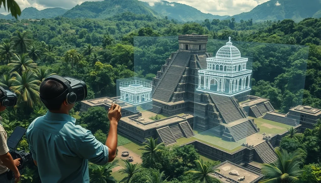
The integration of Virtual Reality (VR) and 3D modeling tools into Maya archaeological research represents a paradigm shift in how ancient Mesoamerican sites are documented, analyzed, and preserved. Traditional archaeological methods often rely on two-dimensional maps and static photographs, which limit the researcher’s ability to understand spatial relationships within complex architectural environments. Digital heritage technologies now allow scholars to reconstruct ancient cities in virtual spaces, enabling “pedestrian perspective” analysis that was previously impossible without physical presence at fragile heritage sites. This technological evolution supports the preservation of cultural heritage while facilitating rigorous scientific inquiry into Maya architecture, urban planning, and landscape interaction.
Main Explanation
Virtual Reality and 3D modeling in this context refer to a suite of technologies including photogrammetry, laser scanning, and Web-based Geographic Information Systems (WebGIS). These tools create digital twins of archaeological sites that can be manipulated, measured, and explored remotely. A primary innovation in this field is the development of 3D WebGIS platforms, such as QueryArch3D, which bridge the gap between traditional GIS spatial analysis and immersive 3D visualization. While standard GIS offers bird’s eye views of landscapes with extruded building footprints, it often lacks the granularity for ground-level interaction. Conversely, standalone 3D models visualize data in three-dimensional space but frequently lack robust analytical tools beyond simple rotation or lighting effects.
The convergence of these approaches allows researchers to search and query segmented 3D models of multiple resolutions in real time. This capability is crucial for studying the eighth-century Maya kingdom of Copan in Honduras, where architecture and landscapes are deeply interconnected. By linking computer-assisted design (CAD) and reality-based models to spatially referenced data, archaeologists can analyze structural relationships, visibility patterns, and spatial usage without risking damage to the physical site. These virtual research environments integrate data from various disciplines, including art history, geosciences, and remote sensing, fostering an interdisciplinary approach to understanding Maya civilization.
Evidence & Sources
The efficacy of these tools is demonstrated by established international projects such as the MayaArch3D Project. Published in Literary and Linguistic Computing in 2013, the project outlined the necessity for a 3D WebGIS with analytical tools capable of handling complex archaeological data. The MayaArch3D system was built as a web-based 3D-GIS specifically for the documentation and analysis of complex archaeological sites, focusing on the UNESCO World Heritage site of Copan. The project was an interdisciplinary effort involving institutions from Germany, the United States, Italy, and Honduras, including the Deutsches Archäologisches Institut (DAI), ETH Zurich, and the Universidad de Heidelberg.
Further evidence of technological advancement is found in recent developments from institutions like UC San Diego. A 2022 study detailed an automated pipeline for reconstructing and displaying cultural heritage sites in VR environments. This pipeline utilizes RGB-D cameras and visual-inertial Simultaneous Localization and Mapping (SLAM) to track cameras and perform 3D reconstruction using registered depth and RGB data. The system facilitates loading reconstructions into VR and creating virtual voice-guided tours, demonstrating the evolution from static models to interactive, immersive experiences. These sources confirm that digital tools are not merely illustrative but are integral to modern archaeological workflows, allowing unskilled users to move from data capture to immersive virtual tours.
Deep Dive Analysis
Technology Description
The core technology underpinning this research is the 3D WebGIS, exemplified by the QueryArch3D tool. This system allows distinct approaches—spatial analysis and 3D visualization—to “talk to each other.” It integrates 3D models of cities, landscapes, and objects with associated, geo-referenced archaeological data. Complementary technologies include visual-inertial SLAM for camera tracking and RGB-D cameras for scene reconstruction, which capture both color and depth information to create accurate digital replicas.
How It Works
The system operates by segmenting 3D models into multiple resolutions, allowing users to query specific architectural features while maintaining context within the larger landscape. In the UC San Diego pipeline, the process begins with tracking cameras using visual-inertial SLAM, followed by 3D reconstruction using registered depth and RGB data. The reconstruction is then loaded into a VR environment where users can interact with the space. This workflow ensures that the digital model retains spatial accuracy relative to the real-world coordinates of the site.
Field Workflow
The field workflow involves data capture using advanced scanning technologies, followed by processing through automated pipelines. In the MayaArch3D project, data was gathered from various institutions that have excavated at Copan since the mid-nineteenth century. Objects from Copan and related archives are dispersed in collections around the world, and the 3D WebGIS serves to integrate these dispersed digital collections. The workflow moves from raw scan data to segmented models linked to databases, enabling real-time querying via a virtual reality environment.
Output/Data
The primary output is a virtual research environment containing basic information for ancient Maya cities in Central America, with a specific focus on Honduras and Copan. The data includes segmented 3D models, computer-assisted design files, and reality-based models linked to spatially referenced metadata. This allows for complex spatial analysis of 2.5D data alongside true 3D interaction, providing both bird’s eye views and ground-level perspectives.
Example
The case study for these technologies is the ancient Maya city of Copan, Honduras. The MayaArch3D Project used digital collections to demonstrate the system’s capabilities on Copan’s archaeology. Researchers could analyze the eighth-century Maya kingdom’s architecture and landscapes through the QueryArch3D tool, searching segmented models in real time. This example highlights how dispersed archival data and modern scans can be unified in a single digital interface.
Strengths
The primary strength of these tools is the ability to analyze 3D models linked to spatially referenced data without physical constraints. Researchers can “get on the ground” and interact with true 3D models from a pedestrian perspective, which is not possible with standard GIS. Additionally, the automated pipelines reduce the technical barrier, allowing unskilled users to go from data capture to an immersive virtual tour without needing extensive specialized training in modeling software.
Limitations
Despite advancements, individual technologies such as scanning, modeling, and visualization have often been developed independently, creating tension in integration. While 3D models visualize data in 3D space, analytical tools in some environments remain simple, limited to rotation or lighting effects unless integrated with a WebGIS. Furthermore, the preservation of cultural heritage sites using these technologies must balance the need for usable land with digital preservation, acknowledging that digital models are supplements to, not replacements for, physical conservation.
Accuracy
Accuracy is maintained through the use of photogrammetry, remote sensing, and registered depth data. The MayaArch3D project involved experts in geosciences and 3D optical metrology to ensure high-fidelity representations. The UC San Diego pipeline emphasizes registered depth and RGB data to ensure the reconstruction matches the physical reality. However, accuracy depends on the quality of the initial scan and the resolution of the segmented models used in the WebGIS.
Cultural Heritage Considerations
There is an ongoing tension between the preservation of cultural heritage sites and the need for usable land. Digital tools offer a method to preserve sites virtually even if physical access is restricted. The MayaArch3D project brings together cultural resource managers with archaeologists to ensure that digital documentation supports conservation goals. By creating virtual tours, these tools also increase public access to heritage sites like Copan without increasing physical foot traffic that could degrade the ruins.
FAQ
What is the MayaArch3D project?
The MayaArch3D Project is an international, interdisciplinary initiative that built a virtual research environment for the documentation and analysis of complex archaeological sites, specifically functioning as a web-based 3D-GIS.
Which archaeological site is the primary case study for these tools?
The UNESCO World Heritage site and ancient Maya city of Copan, Honduras, is the primary case study used to demonstrate the system’s capabilities.
How does 3D WebGIS differ from standard GIS?
Standard GIS allows for complex spatial analysis of 2.5D data with bird’s eye views, whereas 3D WebGIS allows researchers to interact with true 3D models from a pedestrian perspective in a virtual reality environment.
Leave a Reply