
Short Answer
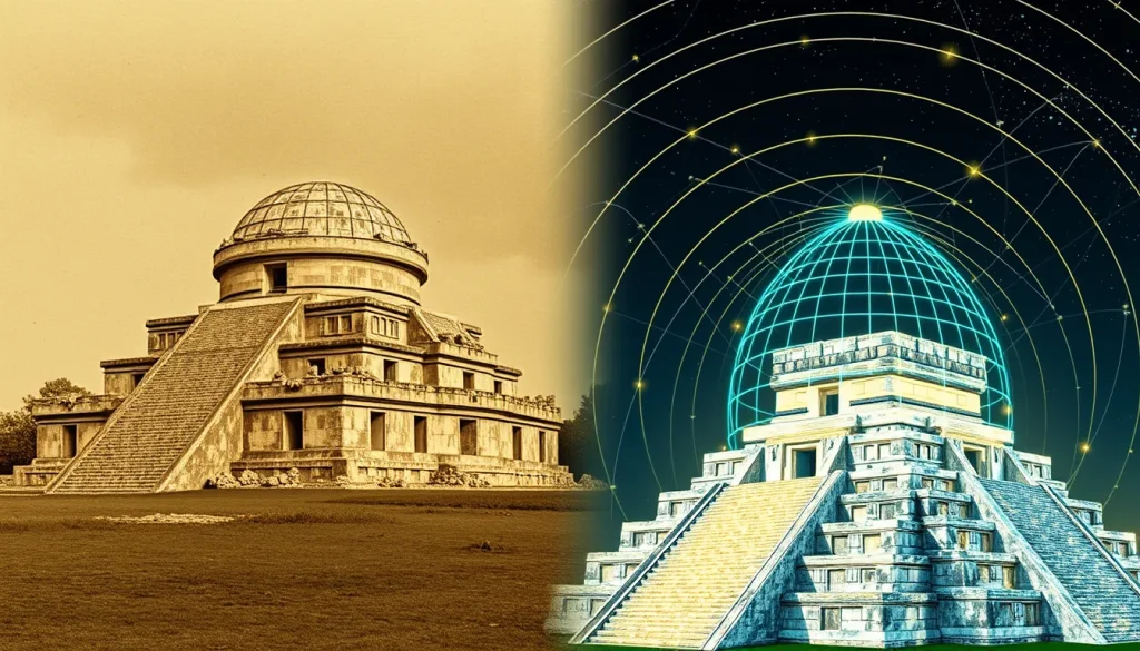
The digital reconstruction of ancient Mesoamerican architecture represents a critical intersection of archaeology, heritage preservation, and advanced computational technology. El Caracol, the renowned observatory temple at Chichén Itzá, stands as a testament to Maya astronomical sophistication, yet its physical structure has undergone significant changes since its abandonment. The process of creating accurate digital models of El Caracol’s dome, particularly regarding its condition before and during early 20th-century reconstruction efforts, presents unique methodological hurdles. Researchers must reconcile fragmentary physical evidence with historical photographic archives while adhering to rigorous academic standards that avoid speculative embellishment.
Main Explanation
The primary challenge in digitally reconstructing El Caracol’s dome lies in the scarcity of precise metric data regarding its pre-reconstruction state. Before the stabilization and reconstruction efforts documented in the early 1900s, the structure existed in a state of ruin. Historical records, such as those preserved in the Peabody Museum archives, indicate that the building was photographed in detail to capture its condition before reconstruction began. These images serve as the foundational data for any digital restoration, yet they lack the three-dimensional depth required for precise modeling without advanced processing.
Architecturally, the Maya corbelled vault presents specific geometric complexities. Unlike true arches, corbelled vaults rely on stacked stones that progressively overlap until they meet at the apex. In a damaged state, determining the original curvature and height of the dome becomes speculative if the capstone or upper courses are missing. Digital specialists must infer these missing elements based on comparative analysis with intact Maya structures or mathematical modeling of vaulting techniques. Furthermore, the reconstruction efforts themselves, documented circa 1911, altered the physical site. A digital model must therefore distinguish between the original ancient construction and the early 20th-century interventions performed by archaeologists and laborers.
Another significant hurdle is the integration of astronomical alignment into the digital model. El Caracol is widely interpreted as an observatory, with windows and shafts aligned to celestial events such as the extremes of Venus. A accurate digital reconstruction must not only replicate the masonry but also validate these sightlines virtually. If the dome’s height or the wall thickness is modeled incorrectly, the simulated astronomical alignments may fail, leading to erroneous conclusions about the building’s function. Therefore, the digital reconstruction is not merely an artistic rendering but a hypothesis testing tool that requires high geometric fidelity.
Evidence & Sources
The evidentiary basis for reconstructing El Caracol relies heavily on institutional archives and historical publications. The Peabody Museum of Archaeology and Ethnology at Harvard University holds a critical collection of photographs documenting the site. Object records such as Caracol, detail of condition before reconstruction (Object Number 58-34-20/30436) provide visual evidence of the structure’s decay prior to intervention. These records are essential for understanding the loss of material over time and identifying which sections of the dome are original versus restored.
Complementary to the museum archives are historical publications like The Wonders of the World, published circa 1911. Images from this period capture El Caracol before its major reconstruction, offering a snapshot of the ruin state. These photographs, while valuable, are two-dimensional and subject to lens distortion and perspective errors common in early photography. Modern researchers must correct these distortions to extract usable metric information. Additionally, records describing the reconstruction process, including details about laborers and excavation departments, highlight the human element involved in the physical restoration, which must be accounted for when analyzing the current structure’s integrity.
Contemporary academic studies provide the methodological framework for processing this historical data. Research into Structure-from-Motion (SfM) techniques demonstrates how historical images can be used to generate 3D digital reconstructions of collapsed or damaged domes. While some studies focus on later collapses, the photogrammetric principles remain applicable to the earlier degradation seen at Chichén Itzá. These studies emphasize that historical images are sometimes the only remaining evidence of destroyed assets, making their digital preservation and analysis vital for cultural heritage. However, they also note the limitations of relying solely on archival photos without ground-truthing via laser scanning of the existing remains.
Deep Dive Analysis
To understand the technical complexities involved, one must examine the specific digital archaeology workflows applied to such projects. The following analysis outlines the technological framework used to reconstruct damaged heritage structures like El Caracol.
Technology Description
The core technology employed is photogrammetry, specifically Structure-from-Motion (SfM) algorithms. This computational process analyzes multiple overlapping 2D photographs to reconstruct 3D geometry. In the context of El Caracol, this involves digitizing glass plate negatives or early prints from the 1911 era and processing them through modern software pipelines.
How It Works
SfM algorithms identify common feature points across multiple images taken from different angles. By triangulating these points, the software calculates the camera positions and generates a sparse point cloud. This cloud is then densified to create a mesh representing the surface of the structure. For historical images, this process is complicated by the lack of controlled camera calibration data known in modern photography.
Field Workflow
In a modern context, the workflow begins with archival research to locate all available historical imagery. Once digitized, images are assessed for quality, overlap, and lighting consistency. Concurrently, terrestrial laser scanning (LiDAR) of the current physical site is conducted. This modern data serves as a control network to scale and orient the historical model, ensuring that the digital reconstruction aligns with the present-day ruins.
Output/Data
The final output is a textured 3D mesh that can be viewed in virtual reality environments or used for structural analysis. Metadata associated with the model includes confidence intervals for different sections of the dome, indicating which parts are based on solid evidence and which are interpolated. This transparency is crucial for academic integrity.
Example
Studies utilizing SfM techniques from historical images have successfully reconstructed domes collapsed in later decades, proving the viability of the method for heritage sites. Applying this to El Caracol allows researchers to visualize the transition from ruin to reconstructed monument, isolating the 1911 restoration work from the ancient Maya construction.
Strengths
The primary strength of this approach is the ability to visualize lost or altered states of heritage sites without physical intervention. It preserves the visual record of the reconstruction process itself, which is historically significant. Additionally, it enables non-invasive testing of astronomical hypotheses by simulating light and shadow within the virtual model.
Limitations
Reliance on historical images introduces uncertainty. Early photography often lacked consistent scale references, making metric accuracy difficult to achieve without ground control points. Furthermore, occlusions in photographs (areas hidden from the camera) require speculative modeling, which must be clearly marked as interpretive rather than factual.
Accuracy
Accuracy is contingent on the quality of the archival photos and the density of the modern scan data used for calibration. While surface textures can be highly accurate, internal structural details remain hypothetical. Researchers must quantify this uncertainty, often using color-coded maps to show variance between the model and known measurements.
Cultural Heritage Considerations
Digital reconstruction raises ethical questions regarding representation. There is a risk of presenting a speculative model as absolute truth, potentially misleading the public about the ancient structure’s original appearance. Institutions like the Peabody Museum note that collections records may contain language reflecting past practices, and modern digital projects must similarly address historical biases in how reconstruction was documented and performed. The goal is to provide a tool for education and research that respects the integrity of the original Maya builders while acknowledging the layers of intervention that followed.
FAQ
Why is reconstructing El Caracol's dome digitally challenging?
Challenges include the lack of precise metric data in historical photographs, the complexity of the Maya corbelled vault geometry, and the need to distinguish between ancient construction and early 20th-century restoration work.
What sources are used for the digital reconstruction?
Researchers use historical photographs from archives like the Peabody Museum (circa 1911) and modern laser scanning data, processed using Structure-from-Motion (SfM) algorithms.
Does the digital model confirm the observatory theory?
The model allows researchers to simulate astronomical sightlines virtually. While it supports the theory of Venus alignments, accuracy depends on the geometric fidelity of the reconstructed dome height and wall thickness.

Leave a Reply