
Short Answer
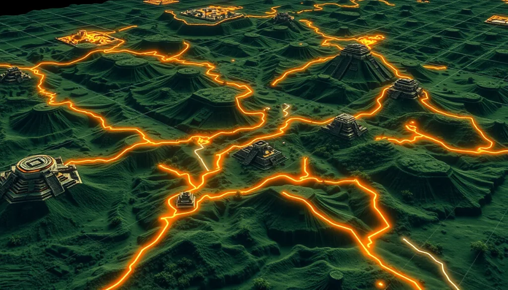
Geographic Information Systems (GIS) have fundamentally transformed the methodological landscape of Mesoamerican archaeology, particularly in the analysis of ancient Maya trade routes and geographical interaction. By integrating spatial data with archaeological evidence, researchers can now model movement across complex terrains that were once barriers to understanding. This digital approach allows for the reconstruction of economic networks, communication pathways, and social organization without relying solely on elite-centric historical narratives. The application of GIS provides a quantitative framework to test hypotheses about how the Maya navigated their environment, exchanged goods like obsidian, and maintained political connections across vast distances.
Main Explanation
The core utility of GIS in Maya archaeology lies in its ability to perform least-cost path analysis. This computational method calculates the most efficient routes between two points based on specific variables such as slope, elevation, and land cover. In the context of the ancient Maya, who inhabited diverse ecological zones ranging from dense tropical forests to rugged highlands, understanding movement is crucial. GIS algorithms simulate human movement energy costs, identifying viable pathways that ancient traders and messengers likely utilized. These digital models are not merely theoretical; they are grounded in the physical reality of the landscape as it existed during the Preclassic and Classic periods.
Furthermore, GIS facilitates the integration of disparate datasets. Archaeological sites, artifact distributions, and environmental features can be layered within a single spatial database. This allows researchers to correlate the location of specific material culture, such as San Martin Jilotepeque obsidian or Cotzumalhuapan-style sculptures, with predicted movement corridors. By overlaying settlement patterns with terrain models, archaeologists can distinguish between secular and spiritual landscapes, identifying routes that may have held ritual significance in addition to economic utility. The technology thus bridges the gap between static site maps and dynamic human behavior, offering a nuanced view of regional interaction.
The shift towards digital heritage methodologies also addresses previous limitations in survey intensity. Traditional ground surveys are time-consuming and often limited to accessible areas. GIS enables the extrapolation of data from intensively surveyed zones to broader regions, helping to identify potential sites or pathways that have not yet been physically excavated. This predictive capability is essential for heritage management, allowing institutions to protect vulnerable archaeological features from modern development. As computational power increases, these models become more refined, incorporating hydrological data and vegetation history to recreate ancient environments with greater fidelity.
Evidence & Sources
Recent scholarly work provides robust evidence for the efficacy of GIS in this domain. A 2023 study focusing on the Kaqchikel Maya Region utilized least-cost routes identified by GIS algorithms between prehistoric nodes of interaction in the highlands and Pacific piedmont of Guatemala. The research indicated viable pathways of movement in a regional landscape during the Late Classic period (AD 550–800). By using the distribution of San Martin Jilotepeque obsidian and Cotzumalhuapan-style sculptures as indicators of trade and communication, the analysis determined likely routes through secular and spiritual landscapes in the mountainous area of the Maya central highlands. This work, authored by Eugenia Robinson, Geoffrey E. Braswell, and Francisco Estrada-Belli, demonstrates how material evidence validates digital models.
In the northern Lowlands, research published in Latin American Antiquity in 2023 reported material evidence of roads in the northwestern Maya Lowlands of Chiapas and Tabasco, Mexico. This study included archaeological evidence recovered from field research covering approximately 670 square kilometers and 618 recorded archaeological sites. It presented the physical characteristics of a series of piedmont paths that connected regions in use from the Middle Preclassic (800–300 BC) through the Late Classic (AD 700–900) period. The work by Flavio G. Silva de la Mora highlights the longevity of these infrastructure networks, confirming that GIS models align with physical causeway remnants found in the field.
Additionally, a 2014 thesis by Alexander Rivas evaluated ancient Maya causeways through GIS analysis, specifically looking at five intersite causeway systems including the Mirador Basin and Yaxuna-Coba-Ixil. This early work noted that GIS analyses on ancient Maya causeways had been very limited at the time, marking a turning point in digital archaeological research. More recently, a 2025 conceptual analysis by Diane Z. Chase, Adrian S. Z. Chase, and Arlen F. Chase argued that research in the Maya area has now generated sufficient archeological data to better define past economic systems. They emphasize moving beyond traditional understandings driven by elite strata finds to define complex market and trade route models using comprehensive data sets.
Deep Dive Analysis
Module F: Digital Archaeology
Technology Description: Geographic Information Systems (GIS) are computer-based tools used to store, visualize, analyze, and interpret geographic data. In Maya archaeology, GIS serves as the primary interface for spatial analysis, allowing researchers to manage large volumes of locational data regarding sites, artifacts, and terrain.
How it Works: The system operates by layering vector data (points, lines, polygons) and raster data (grids of cells representing terrain) into a cohesive map. For trade route analysis, Digital Elevation Models (DEMs) are processed to create cost surfaces. Each cell in the raster is assigned a value representing the energy cost to traverse it, based on slope and friction. Algorithms then calculate the accumulated cost from a source point to all other cells, deriving the least-cost path.
Field Workflow: The workflow begins with data collection via ground survey, LiDAR, or satellite imagery. Archaeologists digitize site locations and causeway alignments. Environmental data is sourced from geological surveys. These datasets are cleaned and projected into a common coordinate system. The analysis phase involves running the least-cost algorithms and comparing the output with known archaeological features.
Output/Data: The primary output is a map showing predicted trade corridors overlaid with actual site locations. Statistical data regarding path efficiency and correlation coefficients between model predictions and artifact distribution are also generated. This data helps quantify the likelihood of specific routes being used for economic exchange.
Example: In the Kaqchikel highlands, GIS was used to determine likely routes of trade through mountainous areas during the Late Classic period. The model successfully correlated with the distribution of obsidian and sculptures. Similarly, in the Mirador Basin, GIS analysis helped evaluate intersite causeway systems, revealing the spatial organization of large urban centers.
Strengths: GIS allows for non-invasive analysis of large landscapes, preserving sites while generating data. It handles complex multivariate analysis better than manual methods. It facilitates the integration of environmental and cultural data, providing a holistic view of human-environment interaction.
Limitations: Models are only as good as the input data; inaccuracies in DEMs can skew results. Ancient terrain may differ significantly from modern topography due to erosion or sedimentation. The technology cannot account for social or political barriers that might override physical cost, such as restricted access zones.
Accuracy: Accuracy depends on the resolution of the Digital Elevation Model and the validity of the cost function used. Validation against ground-truthed archaeological evidence, such as the 618 sites recorded in Chiapas and Tabasco, is essential to ensure the model reflects historical reality.
Cultural Heritage Considerations: Digital models must be used ethically, respecting indigenous connections to the landscape. Data sharing should benefit local communities and heritage management agencies. Predictive models can help protect unrecorded sites from looting or development by identifying high-probability zones for archaeological presence.
FAQ
How does GIS help identify ancient Maya trade routes?
GIS uses least-cost path algorithms to model the most energy-efficient routes across terrain, which are then compared with artifact distributions like obsidian to validate trade corridors.
What time periods are covered by GIS road studies in the Maya region?
Studies cover periods from the Middle Preclassic (800–300 BC) through the Late Classic (AD 700–900), depending on the specific region and material evidence.
Can GIS models replace physical archaeological surveys?
No, GIS models are predictive tools that guide physical surveys; they must be validated against ground-truthed evidence such as excavated sites and causeways.





Leave a Reply